

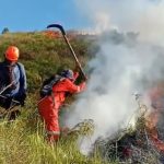


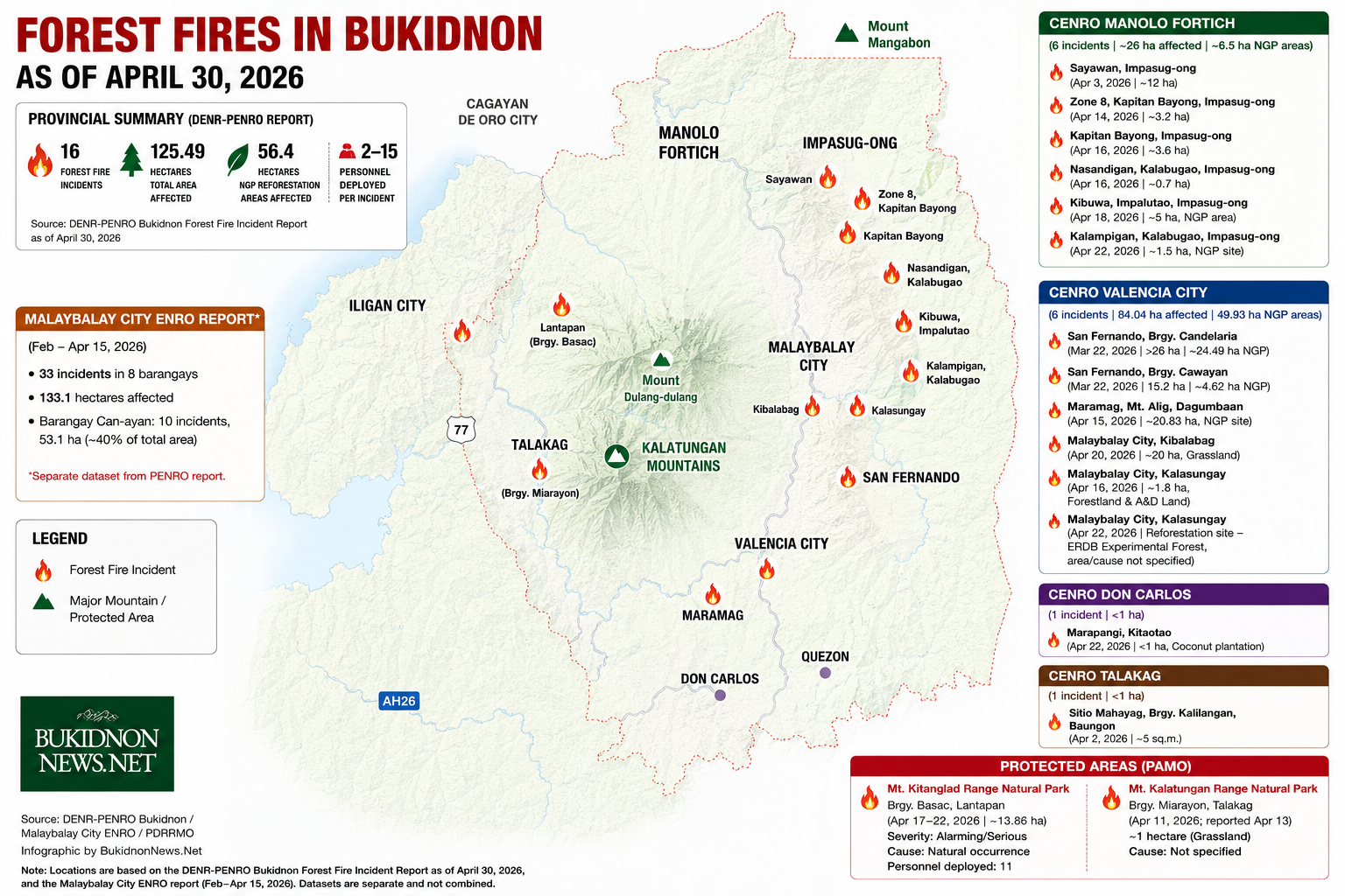
MALAYBALAY CITY (BukidnonNews.Net / 16 May 2026) – The Department of Environment and Natural Resources (DENR) reported at least 16 forest fire incidents across Bukidnon during the height of the dry season. The fires burned an estimated 125.49 hectares, including about 56.4 hectares of National Greening Program (NGP) reforestation areas, based on consolidated data as of April 30, 2026.
DENR’s Provincial Environment and Natural Resources Office’s report covered incidents, which were monitored under the areas of four Community Environment and Natural Resources Offices (CENROs) and two Protected Area Management Offices (PAMOs). Fires hit timberlands, grasslands, reforestation sites, coconut plantations, and protected forest zones in several municipalities and cities across the province.
Areas under CENRO Valencia accounted for about 67 percent or 84.04 hectares of the total area affected by the fires. The DENR report identified 49.93 hectares to be under NGP projects.

NGP-funded projects
Among the notable incidents recorded under CENRO Valencia was the fire in Sitio Kauswagan, Barangay Candelaria, San Fernando on March 22, 2026, which burned more than 26 hectares for still unknown reasons, as of the report’s release. The DENR identified 24.49 hectares of the affected area to be part of NGP.
“The government already graduated the NGP project. DENR has already turned it over to the concerned LGU. Further, the DENR report said they have already advised LGU San Fernando to conduct maintenance and restoration activities.
The NGP, launched by the Department of Environment and Natural Resources (DENR) in 2011, aims to restore degraded forestlands, mitigate climate change, and support upland and Indigenous communities. Expanded in 2015 into the Enhanced National Greening Program (ENGP), it continues rehabilitation efforts through 2028.
The report cited another fire on the same date in Sitio Spring, Barangay Cawayan, San Fernando affecting 15.2 hectares. DENR identified 4.62 hectares of the area as NGP areas.
In Mt. Alig, Dagumbaan, Maramag, a separate fire on April 15 burned about 20.83 hectares, with the entire affected area identified as an NGP site.
The CENRO reported they have already advised an unnamed people’s organization managing the Maramag site to conduct maintenance and restoration activities in the affected area.
All three incidents affected grassland and NGP rehabilitation sites, with causes listed as unknown and severity levels categorized as moderate.
Data from MalaybalayCity
CENRO Valencia also reported additional fire incidents monitored in Malaybalay City. In Kibalabag, fires burned a total of 20 hectares of grassland on April 20 with the cause listed as unknown and severity classified as moderate. On April 16, another fire affected about 1.8 hectares of forestland and alienable and disposable land in Kalasungay.
In the same barangay on April 22, fire also reached a reforestation site identified as an experimental forest of the DENR’s Ecosystems Research and Development Bureau (ERDB). The report did not specify the area affected or the cause of the fire.
The DENR-PENRO data is separate from an earlier Malaybalay City Environment and Natural Resources Office (City ENRO) report, which recorded 33 forest fire incidents across eight barangays in the city from February to April 15, 2026, damaging an estimated 133.1 hectares.
City ENRO data identified Barangay Can-ayan as the hardest-hit area, recording 10 incidents and about 53.1 hectares of burned areas, accounting for around 40 percent of the total affected land in the city. The fires also reportedly damaged around 390 trees, the highest among all barangays monitored (see related story).
Pasture regeneration?
CENRO Manolo Fortich accounted for about 21 percent of the total burned areas, recording six forest fire incidents in April 2026 that affected an estimated 26 hectares of timberland, grassland, and NGP rehabilitation sites, mostly in upland communities of Impasug-ong town.
The largest forest fire incident under CENRO MF hit Sayawan, Impasug-ong on April 3, burning around 12 hectares of grassland within a timberland classification. The report alleged that people set the area on fire “for pasture regeneration.”
Two more incidents hit Kapitan Bayong, Impasug-ong on April 14 and April 16, burning a combined 6.8 hectares of grassland timberland. The first incident in Zone 8 burned around 3.2 hectares, while the second affected another 3.6 hectares. The report also linked both fires to alleged pasture regeneration activities.
In Kibuwa, Impalutao, Impasug-ong, another fire on April 18 damaged around five hectares of an NGP rehabilitation area.
Meanwhile, fire burned about 0.7 hectare of grassland timberland in Nasandigan, Kalabugao, Impasug-ong on April 16, while another fire in Kalampigan, Kalabugao on April 22 affected around 1.5 hectares of an NGP site. The report listed the causes of both incidents as unknown.
The data showed that people allegedly burned at least 18.8 hectares of affected areas under CENRO Manolo Fortich for pasture regeneration, highlighting recurring concerns over land management and fire control practices during the dry season. Two incidents affecting a combined 6.5 hectares struck NGP rehabilitation areas, raising concerns over the vulnerability of government reforestation efforts to forest fires.
Response operations across the six incidents involved a total deployment of 19 personnel, with responders ranging from two to five personnel depending on the scale and location of the fires.
CENRO Don Carlos and CENRO Talakag both reported less than a hectare of forest fires as of April 2026.
Protected areas
Beyond timberlands and reforestation sites, fires also reached protected mountain ecosystems in Bukidnon.
One of the major incidents hit areas in Barangay Basac, Lantapan within the protected area and multiple-use zone of Mt. Kitanglad Range Natural Park. The fire affected around 13.86 hectares of grassland, cultivated areas, and open forest between April 17 and 22. The report classified the incident under an “alarming/serious” severity level and listed the cause as a “natural occurrence.” Authorities deployed 11 personnel during the response operations.
The report noted that most affected portions of the protected area were located adjacent to cultivated farmlands. In response, the Protected Area Management Office said it would intensify Information, Education, and Communication (IEC) campaigns and strengthen fire suppression efforts among barangay officials, Indigenous Peoples Mandatory Representatives (IPMRs), and local communities in the area.
Protected Area Superintendent Roy Aguanta also reported an estimated one-hectare grassfire in Barangay Miarayon, Talakag that burned on April 11 and was reported on April 13 under the jurisdiction of the Protected Area Management Office (PAMO) of Mt. Kalatungan Range Natural Park.
The DENR consolidated report showed that several incidents remained under “unknown” causes, underscoring the challenge of monitoring fires across vast upland and forested areas during prolonged dry weather conditions.
Personnel deployment during response operations ranged from two to 15 responders depending on the severity and location of the fires.
The consolidated report formed part of the provincial government’s broader disaster risk reduction and management efforts amid anticipated impacts of El Niño and prolonged dry conditions.
BukidnonNews.Net obtained a copy of the DENR consolidated report from the Provincial Disaster Risk Reduction and Management Office (PDRRMO).
In its request letter dated April 24, the Provincial Disaster Risk Reduction and Management Office said the data would serve as “critical input in risk assessment, contingency planning, and the development of appropriate preparedness and mitigation measures for the province.” (BukidnonNews.Net)